The Rock
|
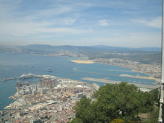
Looking out over Gibraltar's land reclaimed from the sea. Spain in just beyond the airfield.
|
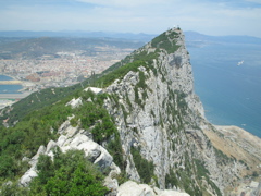
May 7, 2005 - The Rock of Gibraltar. Towering more than 400m above the sea, it overlooks the straits, the narrow neck of land to mainland Spain, and the modern city of Gibraltar. The Rock of Gibraltar was raised from the Jurassic sea floor 200,000,000 years ago, explored by the Greeks, Carthiginians and Romans in classical times, occupied by the Moors in 711, conquered by the Spanish in 1462, captured by the British in 1704, and now we've visited it. |
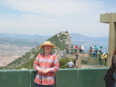
Robin does the rock.
|
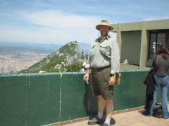
Will does the rock.
|
The observation platform at the cable car terminal at the top of the rock. Will and Robin pose for "yep, I was really there" pictures. This is the first stop on our walking tour of the Rock.
We rode the cable car from the bottom to the top of the rock (or technically 36 ' from the top). Most of the rock is a nature preserve now, so there are only 2 cars that go up (and down) - each holding around 30 people. It was awesome!
|
no one wants to play!
|
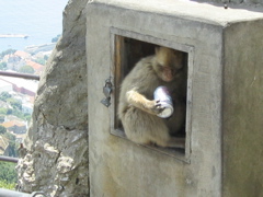
Investigating a Coke can.
|
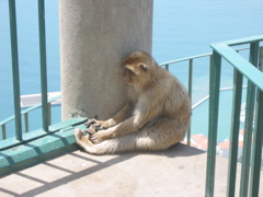
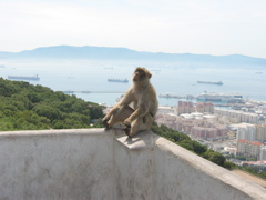
The upper part of the rock is occupied by a colony of apes (they're the ones with the fur coats). Legend says that if the number of apes drops below 34, the British will loose Gibraltar, so the British take no chances. During WWII, when the numbers ran low, they brought in reenforcements. The current colony is about 350 apes. They are fed, tagged (tattooed), monitored by vetinarians, and they are everywhere. They will steal any food or plastic bags (all plastic bags contain chips) they can get their hands on. They also like Coke cans. The snack bars all have warnings not to take any food outside. |
Mugging for the tourists.
|
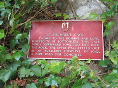
Entrance to St. Michael's cave.
|
The little apes are everywhere you look. They like shady spots, at least they do on days like today (around 75 degrees and sunny at dockside). They scamper from ledge to person to ledge to tree to car top (even with the car moving) to tree....
We walked from the top down a roadway to St. Michael's cave. It took about 20-25 minutes and was a bit steep. Lush vegetation grows in every crease it can find. Took lots of pictures and will add them when we get home.
|
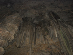
Stalagtites
|
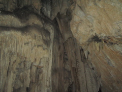
and more stalagtites.
|
St. Michael's Cave is a natural limestone cave in the rock of Gibraltar. This is considered a "live" cave as water still seeps through the rock and leaves its deposits on the stalagmites and stalagtites. It is quite deep and we were only permitted into the top layer. They hold concerts in it and the acoustics are lovely. The lower layers are open to researchers and are accessible with ropes only. There is a natural lake in the lower level and they don't know the actual depth of the water. |
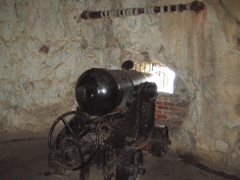
Cannon at one of the gunports in the siege tunnel.
|
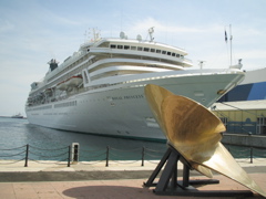
Our ship, the Royal Princess, docked at Gibraltar's port.
|
The siege tunnels were begun during the Great Seige (1779-83) when the Spanish and French tried to take Gibraltar back from the British. The tunnels were carved by hand and gunpowder and used to mount cannon where they could fire down on the attackers. In the years after the siege, the tunnels were greatly extended. By the time they were done they had enough tunnels, more than 30 km, to house the entire garrison.
We walked down to the heart of the tunnels - an area that was used to, among other things, serve President Ulysses S. Grant a meal. Then we had to walk back up.
After all that, we make our exhausted way back to the ship.
|